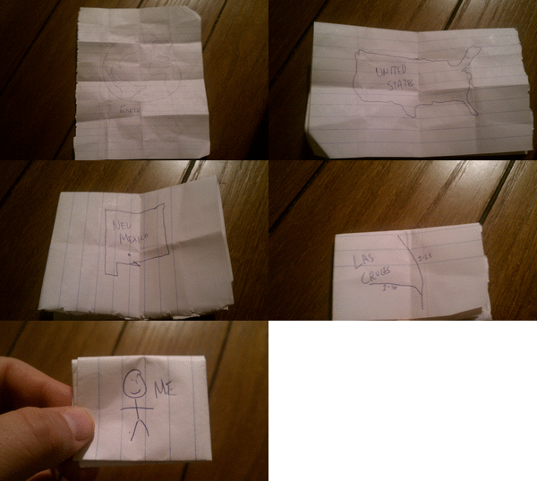
I am currently working on a unit resources page about geography. In 5th grade I teach United States geography, states and capitals, and map skills, but also briefly touch on world geography. I've noticed a disturbing trend over my career. Students in the 5th grade don't often know the difference between countries, states, and continents. They have no concept of distance (they think China is next to Mexico, etc.), and think that major cities are states (countless students have called Los Angeles a state, or California a city, or thought that Los Angeles was California). I like to include this very simple activity I call Zoom Maps. All you need for this activity is a sheet of paper, and something to write with. This is obviously an activity that can be done with much younger students, but I've found success with it in both social studies and science. I do this same foldable to "zoom in" to an atom.
Check out this example I drew up. It's very crude, but it is easy to follow. I hope to upload some student examples once school starts (August 15th here in Las Cruces). CLICK HERE FOR THE PDF DOCUMENT. Enjoy!
Also, here is an animated gif of my very simple and crude example. I made this at Picasion.
Here's a simple post with a simple premise, the seven continents. You'd be surprised how many fifth graders (pretty much most of them) don't know the seven continents, or think that Texas and California are both continents.
I'm going to keep this nice and easy. I don't really have a lot of extra time to teach the continents, but I like for that content to get taught. So, I'll have my students practice by playing the Continent Names game over at PlayKidsGames.com. Next up, I will have them listen to this rap called "The Continents Song." It's a little infectious, easy to pick up, and within a week, the kids know the names of the seven continents. That was easy!
In the state of New Mexico, Earth & Space Science has a prominent place in the standards and benchmarks, especially in 5th grade. This being one of the primary topics students learn about in science class, as well as being the yearly focus for students participating in the after school science program run by SEMAA, it's important to have a few resources ready to utilize.
---------First, there is the ubiqutous Google Earth. It's a free download, and I've found that it runs pretty well on school servers. The great thing about Google Earth is the vast amount of ways it can be utilized. When using Google Earth, the first thing kids will want to do is locate either their own home or the school. It's important to give them this freedom. It helps them learn the controls, and get used to the software. If your computers have the capability, let students put pins on the places they find for future reference. Also, you can turn it around and get detailed renderings of the Moon and Mars, as well as the stars from a distance.
The first activity I usually do with Google Earth, and the students are still learning it, involves zooming to a certain point, taking a screen capture, then pasting that screen capture in a Word document (I have students push the print screen button, crop the resulting image in MS paint, then paste that in MS Word). I ask my students to start with a picture of the Earth, and zoom in using major points of reference, evenutally reaching their house or the school. This usually results in students zooming from earth, Western Hemisphere, North America, United States, New Mexico, and then into the county, city, neighborhood, then the final image is the target. This does a great job of teaching the controls, and how to do some simple copying, cropping, and pasting between the Google Earth program and a document.
---------Next up is Celestia, an awesome free download that is similar to Google Earth. What makes Celestia different from Google Earth is that instead of focusing on Earth (as well as Mars and the Moon), is that you can zoom in on the cosmos, and see the stars up close. Celestia helps drive that point home that the universe is really big, and the Earth is just a speck of dust in relation.
--------Now for a couple of great videos:
Cosmic Zoom is by far one of the most endearing videos in terms of teaching about the immense size of the universe, and our place in it. It's made even better by the fact that it's narrated by Morgan Freeman. The last few minutes of this video zoom into an atom, so it's great for teaching both about the scale of the universe and the atomic scale as well. It's eerie how similar the two seem in the end:
Pale Blue Dot by Carl Sagan might not hit kids as hard as it does adults, but it really puts the overall scale of the Earth as it relates to our galaxy and the greater universe in perspective. I've found that even elementary school aged kids enjoy watching this video and have a lot of great questions afterwards:
The Hubble Deep Field is a stunning video that nearly brought this science nerd to tears the first time I saw it. I show this to students because it's just amazing to see (if you're in a hurry, fast forward up to the 5 minute mark to catch the deep field portion of the video).