I am currently working on a unit resources page about geography. In 5th grade I teach United States geography, states and capitals, and map skills, but also briefly touch on world geography. I've noticed a disturbing trend over my career. Students in the 5th grade don't often know the difference between countries, states, and continents. They have no concept of distance (they think China is next to Mexico, etc.), and think that major cities are states (countless students have called Los Angeles a state, or California a city, or thought that Los Angeles was California). I like to include this very simple activity I call Zoom Maps. All you need for this activity is a sheet of paper, and something to write with. This is obviously an activity that can be done with much younger students, but I've found success with it in both social studies and science. I do this same foldable to "zoom in" to an atom.
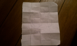
Check out this example I drew up. It's very crude, but it is easy to follow. I hope to upload some student examples once school starts (August 15th here in Las Cruces).
CLICK HERE FOR THE PDF DOCUMENT. Enjoy!
Also, here is an animated gif of my very simple and crude example. I made this at
Picasion.

No comments:
Post a Comment
All comments on this blog will be moderated, please stay on topic and refrain from using profanity. Spam will simply be ignored.